
Inventory infrastructure, assess its condition and prioritise interventions to manage road assets better on a tight budget.
Local authorities must maintain pavements, signage and street furniture while keeping public spending under control. Their technical departments identify the work required, prioritise it and prepare works programmes that fit the available budgets. Reliable, up-to-date knowledge of the assets helps allocate resources more effectively and present decision-makers with documented needs.
The need: identifying priorities before committing spending
To plan maintenance of its network, a local authority needs to know:
- Which road sections need priority intervention?
- Which assets show visible deterioration?
- What can be observed remotely, and what needs an on-site inspection?
- How does network condition compare between two surveys?
- How can the proposed works be justified and budgeted?
The challenge: moving from fragmented knowledge of the assets to structured management that directs investment towards identified needs, without multiplying inspection trips.
The response: mobile mapping and artificial intelligence
Surveys carried out with Imajbox® systems provide georeferenced documentation of pavements, street assets and their surroundings, available from the office. Imajnet® AI models automate part of the inventory and analysis, and the results are centralised in Imajnet® where they can be checked, enriched and shared.
Data collection and analysis are adapted to the area studied, the maintenance objectives and the resources available.
From network observation to works programming
Document the network
Imajbox® survey campaigns are organised according to the sectors to be monitored and the required update frequency. Georeferenced images let teams examine pavements and assets without systematically returning to the field.
Detect assets and deterioration
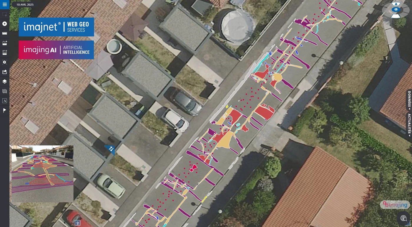
Imajnet® AI models detect and georeference cracks and potholes, road markings, traffic signs, street lighting and traffic lights to build structured inventories.
Check data and track changes
In Imajnet®, teams review and complete the detections. Comparing survey campaigns reveals changes and helps target field inspections.
Prioritise interventions
Combined with the authority’s existing data, the observations help teams set priorities based on observed condition, network use, safety issues and available resources.
Prepare investments
Inventories are shared between departments or exported to the authority’s GIS to estimate needs, define works programmes and prepare budget decisions.
Imajnet® AI data export formats
- Shapefile (.shp)Point, line and polygon layers for QGIS, ArcGIS and most GIS software.
- GeoPackage (.gpkg)Open GIS format bundling layers and attributes in a single file.
- KMLViewing in Google Earth and map viewers.
- CSVAttribute tables for spreadsheets, asset databases and maintenance applications.
- WFS serviceLive access to the results from your GIS, without exporting files.
Detections are reviewed and corrected in Imajnet® Gecko before export. The data can also be used in QGIS through the Imajnet plugin, or processed further in Imajview®.
Tailored to each stakeholder’s responsibilities
Technical departments
Monitor infrastructure condition, identify sectors to inspect and prepare interventions.
Engineering firms and contractors
Carry out surveys, analyse the data and deliver the inventories needed for studies and maintenance programmes.
Budget managers and elected officials
Rely on summaries prepared by technical teams to compare needs, decide priorities and plan spending.
Everyone shares a common reference, from network observation through to decision-making.
Benefits for public asset management
Controlled operating costs
Remote image review and automated analyses reduce inspection trips and the time spent on manual inventories.
Better network knowledge
Georeferenced data makes infrastructure easier to locate and monitor; successive surveys keep the documentation up to date.
Gradual deployment
Data collection can be organised sector by sector and analyses tailored to the chosen objectives.
Better-documented decisions
Elected officials and technical managers share a common basis to structure programming, argue priorities and prepare budgets.
Turning asset knowledge into a decision-making tool
By combining mobile mapping, AI image analysis and shared geospatial data, local authorities can monitor their network more efficiently and better align technical needs, intervention priorities and financial capacity.